ls ~/work

Work.

Clients I've worked with, and the projects we've shipped together.

$ ls ~/work → 29 projects

TheTreeMap

Environmental monitoring

2 projects

  • Nusantara Atlas

    2016⁠–⁠2026 · lead front-⁠end · build, feature development & modernization

    Monitors deforestation, fires, peat degradation, and forest regrowth across Indonesia, Malaysian Borneo, and Brunei, while tracking the impact of the palm oil, pulp and paper, mining, and timber industries. One map combines near real-time RADD and GLAD deforestation alerts, daily VIIRS and MODIS fire hotspots, concession and palm oil mill maps for supply chain traceability, satellite time-lapses that export to GIF, and two decades of annual deforestation down to district level.

    It grew from a simple map into an analysis platform. Its modernization moved it to a stack that stays maintainable for the long term, migrated some services to open source, and optimized the map layers, cutting yearly costs by about 60%. It now has 4,000+ users, 145+ premium users, and 7+ organizations on premium subscriptions, and has been featured 40+ times in major global and Indonesian media.
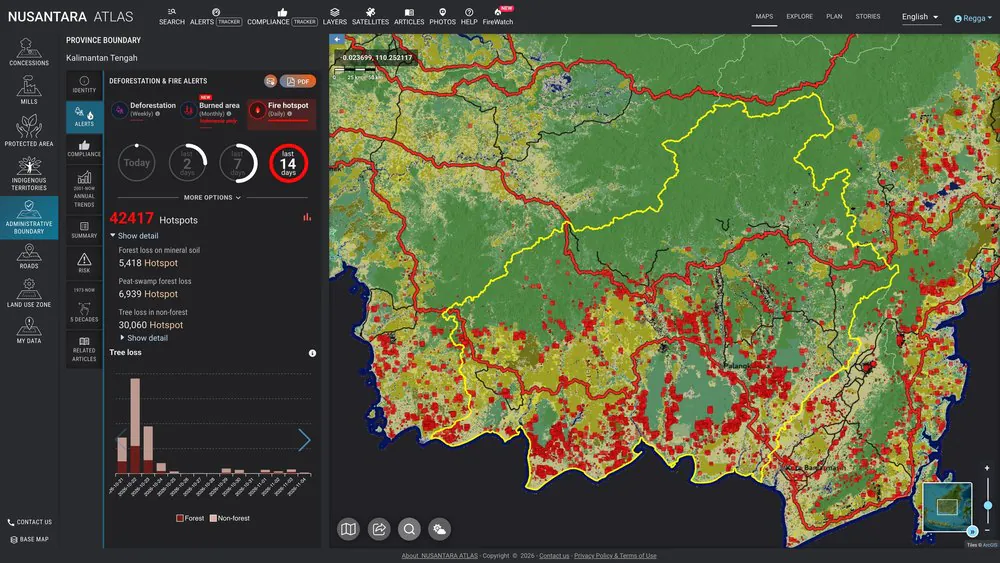
    Nusantara Atlas: deforestation and fire alerts map for Central Kalimantan with the analysis panel
    [web-⁠map] [data-⁠viz] [modernization] [devops]visit site ↗ (opens in a new tab)
  • Nusantara Atlas Stories

    2022

    The stories section of Nusantara Atlas: articles on deforestation and fires in Equatorial Asia, filterable by topic such as deforestation, fire, palm oil, and peatland.
Optima Logistics

Transportation & logistics

3 projects

  • Shipment tracking

    2026 · feature development & mentoring internal developers

    A customer-facing tracking portal for Optima Logistics. Customers enter their Customer ID and AWB (air waybill) number to see the shipment's status and the delivery vehicle's last known position on a full-screen map. Behind it, a REST API gives each customer their own profile, AWBs, and live GPS tracking for packages still on the road.

    customer access only

    [web-⁠map] [front-⁠end] [api]
  • Server migration & modernization

    2026 · hands-⁠on execution & mentoring internal developers

    Migration to a new server running the latest OS, NGINX, PHP, and database, with security hardening and modernization: containerization, version control, and CI/CD.

    [modernization] [devops]
  • Integrated Logistics & Fleet Management System

    2016⁠–⁠2018 · build, feature development & maintenance

    A real-time centralized platform for managing air waybills, invoices, shipment tracking, fleet operations, employee management, and business performance analytics.

    internal system

    [front-⁠end] [back-⁠end] [data-⁠viz]

Global Landscapes Forum

Knowledge platform & events

2 projects

Landscape Alliance

Operating name of CIFOR-ICRAF

2 projects

  • Stakeholder Engagement With Evidence Hub

    2026

    A hub that includes the Stakeholder Engagement Approach to Risk-Informed and Evidence-Based Decision-Making (SHARED) toolkit. The interactive toolkit walks practitioners, organizations, and landscape initiatives step by step through assessing and improving how they engage stakeholders, then points them to relevant resources.

  • Landscape Academy

    2026

    A learning platform with free online courses, community, and webinars on landscape restoration and management, delivered in partnership with the Global Landscapes Forum.

    [front-⁠end] [back-⁠end]visit site ↗ (opens in a new tab)

CIFOR-ICRAF

Forestry & agroforestry research

4 projects

  • Digital Assets Collector Engine

    2023⁠–⁠2026 · build, feature development & maintenance

    A knowledge data platform that brings together five separate sources: publications in DSpace, research datasets in Dataverse, photos on Flickr, and records from two internal systems. A harvester, run on a schedule or on demand, maps each source into one shared format and indexes it in Apache Solr as knowledge products, projects, and author profiles.

    An admin back office handles curation with a query builder, harvest logs and schedules, and user accounts. A strictly read-only REST API serves the index as JSON to authorized apps and websites, so newly curated collections reach them with no code changes. The harvester, admin, and API run in containers and ship through a CI/CD pipeline, and a dashboard visualizes the indexed data and harvest statistics.

    internal system

    [back-⁠end] [api] [front-⁠end] [data-⁠viz] [modernization] [devops]
  • WILDMEAT Database Explorer

    2022⁠–⁠2026 · build, feature development & maintenance

    An interactive map of the WILDMEAT database, bringing together research data on wild meat use, including consumption. WILDMEAT is a partnership of CIFOR, the University of Stirling, and WCS.

    Behind the map, a data entry UI and API publish new data: it is stored in Apache Solr, and the API automatically generates a dataset file and sends it to Dataverse. The map reads its data from Solr, while dataset downloads go through the Dataverse API securely, with a login and a one-time access token. Data entry runs as separate components, so updating and publishing data does not disrupt the map.

    [web-⁠map] [front-⁠end] [back-⁠end] [api] [devops]visit site ↗ (opens in a new tab)
  • WILDMEAT Interventions Database

    2022⁠–⁠2023 · build, feature development & maintenance

    An open database of past and active interventions that aim to reduce wild meat hunting, consumption, and trade, or make them sustainable, starting with projects in Central Africa. Each record covers an intervention's conservation and development outcomes, including what worked and what did not, so researchers, practitioners, and policy makers can learn from earlier projects. It launched in 2022 alongside a special issue of the African Journal of Ecology with several hundred projects documented, and the work also included data entry.

    [web-⁠map] [front-⁠end] [back-⁠end] [api] [devops]visit site ↗ (opens in a new tab)
show 1 more project
  • WILDMEAT Ecological Indicators

    2023

    A toolkit of ecological indicators, with the methods and tools to measure them, for wild meat research and monitoring.

CIFOR

Center for International Forestry Research · CGIAR

11 projects

  • Ecological Vegetation Map

    2020

    An interactive ecological vegetation map of West Kalimantan, Indonesia, with 58 vegetation and land-cover classes, from lowland and peat swamp forest to mangroves, plantations, and settlements, interpreted at 1:50,000 from Landsat imagery. Users can toggle layers and download the map of a selected regency as a PDF or shapefile, to support land-use planning such as watershed management and identifying High Conservation Value forests. The data comes from CIFOR and CIRAD research supported by the European Union and USAID.

  • Participatory Models for Biodiversity Conservation

    2020

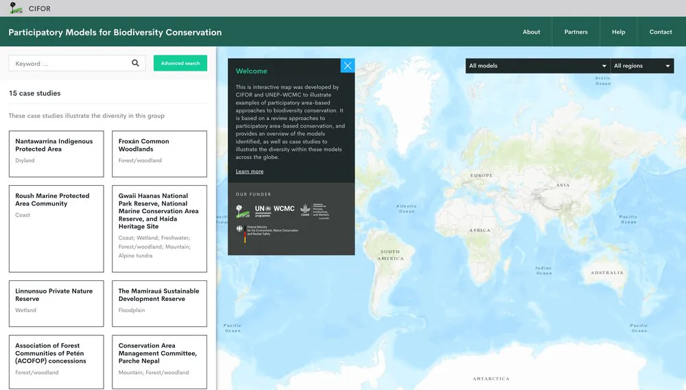
    An interactive proof-of-concept map of participatory, area-based approaches to biodiversity conservation, with case studies from around the world. Built for a research program by CIFOR and UNEP-WCMC, funded by Germany's Federal Ministry for the Environment (BMU).

    Screenshot of the Participatory Models for Biodiversity Conservation website: a searchable list of 15 case studies next to a world map with model and region filters and a welcome panel.
    [web-⁠map]archived
  • Asia-Pacific Rainforest Summit 2018

    2018

    The website for the 3rd Asia-Pacific Rainforest Summit, part of the Asia-Pacific Rainforest Partnership, which brought together governments, business leaders, NGOs, and researchers to share practices that slow, halt, and reverse deforestation in the region.

    [front-⁠end] [back-⁠end]visit site ↗ (opens in a new tab)
show 8 more projects
  • Blue Carbon Summit

    2018

    The website for the Blue Carbon Summit, on the role of Indonesia's coastal blue carbon ecosystems (about 3 million hectares of mangroves and 300,000 hectares of seagrass meadows) in climate change mitigation and adaptation.

    [front-⁠end] [back-⁠end]visit site ↗ (opens in a new tab)
  • Atlas of Deforestation & Industrial Plantations in Borneo

    2016⁠–⁠2018 · build & feature development

    An interactive atlas of deforestation and industrial plantations in Borneo that helps tell apart plantation companies that cleared old-growth forest from those that avoided it, for more effective oversight by certification bodies and governments. It later grew into Nusantara Atlas (opens in a new tab), which now covers Indonesia, Malaysian Borneo, and Brunei.

    [web-⁠map]archived
  • The REDD+ Benefit Sharing Knowledge Tree

    2014

    An interactive tool that guides users through the complexity of sharing benefits from REDD+, developed for a CIFOR project on REDD+ benefit-sharing mechanisms in developing countries, funded by the European Union.

    [front-⁠end] [back-⁠end]visit site ↗ (opens in a new tab)
  • Think Forests

    2014

    A CIFOR campaign site for the Sustainable Development Goals that encouraged people to think about forests every day, with a video competition and wallpaper downloads.

    [front-⁠end] [back-⁠end]visit site ↗ (opens in a new tab)
  • Forests News

    2014

    A redesign of Forests News, CIFOR's blog and multimedia news service with video, infographics, photos, commentary, and analysis on forests, connected to social media, an e-newsletter, and RSS.

    [front-⁠end] [back-⁠end]visit site ↗ (opens in a new tab)
  • The Complexity of Governance

    2014

    An interactive infographic that explains the multi-level, multi-jurisdictional governance of the Madre de Dios landscape in Peru, in English and Spanish.

    [data-⁠viz] [front-⁠end]archived
  • Global Wetlands

    2014

    An interactive map of the world's wetlands, peat, and peat depth, with country and sub-national profiles, side-by-side comparison of up to three areas, and GeoTIFF downloads.

    [web-⁠map] [data-⁠viz]visit site ↗ (opens in a new tab)
  • Forests Asia Summit 2014

    2014

    The website for the Forests Asia Summit in Jakarta, organized by CIFOR and co-hosted by Indonesia's Ministry of Forestry, where ministers, CEOs, civil society leaders, and scientists discussed how Southeast Asia can shift to a green economy. More than 1,000 stakeholders attended, with thousands more following online and through nationwide broadcasts.

    [front-⁠end] [back-⁠end]visit site ↗ (opens in a new tab)

WRI Indonesia

Research institute

1 project

  • Landscape Monitoring Initiative

    2023⁠–⁠2025 · build, enhancement & maintenance

    A platform for companies, local governments, and civil society to prioritize, verify, and report deforestation alerts using before-and-after satellite imagery.

    [web-⁠map] [front-⁠end]visit site ↗ (opens in a new tab)

Basarnas

Government · search and rescue

1 project

  • SIMASDA

    2018

    GIS portal for Indonesia's National Search and Rescue Agency (Basarnas), an integrated web-based information system for disaster planning and response. In 2018, 50 participants from 38 search and rescue offices across Indonesia, along with headquarters staff, were trained to use it.

    internal system

    [web-⁠map] [data-⁠viz]training news ↗ (opens in a new tab)

Islamic Development Bank Group

Multilateral development bank

1 project

  • IsDB Group Indonesia website

    2016

    The website for the IsDB Group Country Gateway Office in Indonesia, opened in 2014 to bring the Bank closer to its stakeholders: government, the private sector, academia, civil society, and development partners.

    [front-⁠end] [back-⁠end]visit site ↗ (opens in a new tab)

KLHK

Ministry of Environment and Forestry · Government of Indonesia

1 project

  • Indonesian National Carbon Accounting System

    2015

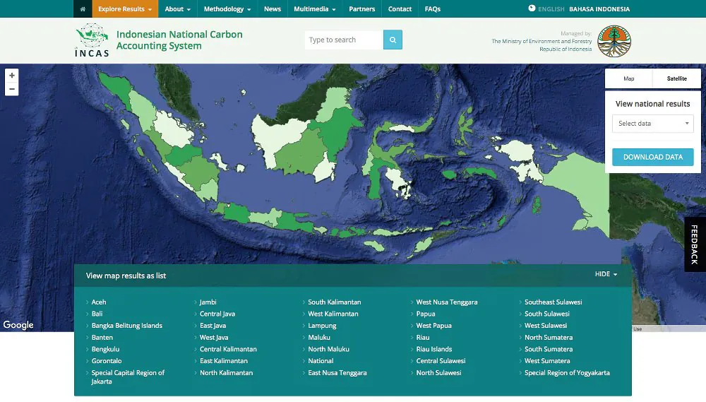
    The website for INCAS, Indonesia's national system for the Measurement, Reporting and Verification (MRV) of greenhouse gas (GHG) emissions, including for REDD+ activities. It presents national and provincial results on an interactive map of Indonesia, with charts, data downloads, and the methodology, definitions, and assumptions behind them, in English and Indonesian. The website was launched at the Global Landscapes Forum in Paris in December 2015, on the sidelines of COP21.

    INCAS is also designed to support Indonesia's broader requirements under the United Nations Framework Convention on Climate Change (UNFCCC), including GHG reporting for the Agriculture, Forestry and Other Land Use (AFOLU) sectors and tracking progress against the country's emissions reduction targets. As a Tier 3 GHG accounting system, it generates detailed information on historical, present, and projected emissions and removals from land-based activities, and it can be scaled to provincial and district levels.

    Screenshot of the INCAS website: a satellite map of Indonesia with provinces shaded in green, a panel to view and download national results, and a list of provinces.
    [web-⁠map] [data-⁠viz] [front-⁠end] [back-⁠end]launch video ↗ (opens in a new tab)archived

The Asia Foundation

International development

1 project

  • Program SETAPAK

    2014 · revamp

    The website for The Asia Foundation's SETAPAK program (2012–2020), which worked to improve forest and land governance in Indonesia, partnering with more than 70 civil society organizations across 10 provinces, with funding from the UK Climate Change Unit.

Have a project in mind?

I can design the solution, lead the project with my own team, or get hands-on as a senior developer with a team of AI agents.